-
Sturt + the inland sea
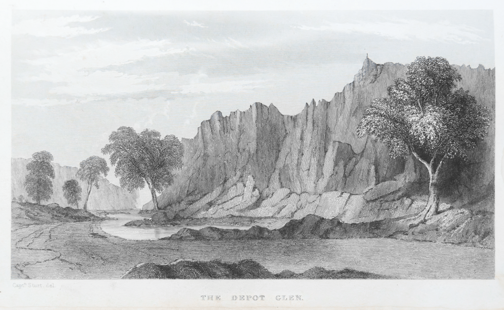
In 1844 Charles Sturt spent a couple of years looking for the inland sea. In 1827, a former East India Company officer Thomas J. Maslen, published this map of the inland sea in his book The Friend of Australia, which provided instructions for surveying and exploring the island-continent’s interior. It was a popular colonial belief that…
-
A Flinders creek bed

A note on Photographic Exceptionalism The pictures are of early morning light on tree roots of red river gums (Eucalyptus camaldulensis,) in Benbibuta Creek in the northern Flinders Ranges of South Australia. They were made with a Rolleiflex TLR whilst I was on a camel trek from Blinman to Lake Frome in 2021. When I…
-
Remembrance?

When I drove through Gawler the other day on my way north I I sent some time walking around the town:. I came across this powerful image in a shop window relating to WW1, and more specifically to November 11, the anniversary of the armistice which ended fighting on the Western Front of what was…
-
Iron Knob + history

When I made a quick visit to the Eyre Peninsula in late 2023 with Maleko, our standard poodle, we camped overnight at Iron Knob in South Australia’s Middleback Range. I wanted to spend some time walking around this old mining town to see what was left. I had briefly visited it in passing through the…
-
Quorn: colonial history + photography

On Wednesday July 27th we cleaned up Nudlamutana hut in the morning, packed the Outback Subaru, and slowly drove to Blinman via the Yunta Road. We had lunch at Blinman — a pastie – -then drove onto Quorn. We stayed in a cabin in the Quorn caravan park and had a pub dinner at the…
-
Kingsmill Creek + Arkaroola reef

As it was mentioned in this earlier post we spent the afternoon of our last full day in the semi-arid mountainous landscape of the Vulkathunha-Gammon Ranges National Park walking in the Kingsmill Creek Gorge. The creek is accessed from the road to the Paralina Hot Springs, which I haven’t been to. We had been to…
-
Acacia Ridge + yellowcake

Tuesday July 26th was our last full day of walking in the Vulkathunha-Gammon Ranges National Park. The plan was to make an early start, walk Acacia Ridge, have morning coffee at Arkaroola Village, walk back to the car along the Arkaroola Rd, have lunch amongst the river gums in the creek bed of Kingsmill Creek, then…
-
Bararranna Gorge: deep time
Monday (July 25th) was the day of the Bararranna Gorge walk. We had walked the Bararraanna Gorge trail last year. We remembered the various waterholes, the Sturt Desert peas in the creek beds and the rock formations in the gorges. The bushwalking groups deem it to be moderately challenging (C+) and it is a popular…
-
At Balcanoona Creek

Sunday (24/7/2022) was a rest day from walking. The plan was for a large format photography session at Balcanoona Creek in the late afternoon after the sun had dipped below the cliffs. In the morning we cleaned up Nudlamutana Hut then drove to the Arkaroola Wilderness Sanctuary for petrol, mobile connection and an ice cream. On the…
-
Italowie Creek Walk
We drove the 30 or so kilometers on the Gammon Ranges Road from the Nudlamutana Hut to the Italowie Gap campsite going past Balcanoona Station and the nearby Echo cliffs. I spent a bit of time wandering around the Gap taking photos of the traces of pastoralism before we started our walk to the gorge…
-
Subscribe
Subscribed
Already have a WordPress.com account? Log in now.
